Westerstede
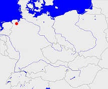
Diese Karte zeigt die Position oder den Umriss des Objekts. Haben Sie einen Fehler entdeckt? Dann würden wir uns über eine Nachricht freuen.
Übergeordnete Objekte
Legende
| | politische Verwaltung |
| | kirchliche Verwaltung |
| | gerichtliche Verwaltung |
| | Wohnplatz |
| | geographische Typen |
| | Verkehrswesen |
Übergeordnete Objekte
-
Oldenburg
(HerzogtumLandesteilVerwaltungsbezirk) (1814 - 1933-05-14)
-
Niedersachsen, Neder-Saksen, Lower Saxony
(LandBundesland) (1946-11-01 - 1978-01-31)
-
Deutschland, Bundesrepublik Deutschland, Allemagne, Duitsland, Vokietija, Niemcy, Nemecká spolková republika, Federal Republic of Germany, Tyskland, Germany, Герма́ния
(Staat) (1949-05-24 -)
-
Europäische Wirtschaftsgemeinschaft, Europäische Gemeinschaft, Europäische Union, Comhphobal Eacnamaíochta na hEorpa, Euroopan talousyhteisö, Európske hospodárske spoločenstvo, Communauté économique européenne, Comunidad Económica Europea, European Economic Community, Comunità Economica Europea, Evropské hospodářské společenství, Europese Economische Gemeenschap, Európske spoločenstvo, Europese Gemeenschap, Euroopan Yhteisö, Comunidad Europea, European Community, Comunità Europea, Evropské společenství, Communauté européenne, Comhphobal Eorpach, Europese Unie, Aontais Eorpaigh, Unione Europea, European Union, Európska únia, Unión Europea, Euroopan Unioni, Evropská unie, Union européenne
(Staatenbund) (1958 -)
-
Vereinte Nationen, Verenigde Naties, Организация Объединённых Наций, Organización de las Naciones Unidas, Organisation des Nations unies, الأمم المتحدة, 联合国, Organizácia Spojených národov, United Nations
(Staatenbund) (1973-09-18 -)
-
Britische Besatzungszone
(Besatzungszone) (1946-11-01 - 1949-05-23)
-
Oldenburg
(GrafschaftHerzogtumHerzogtumGroßherzogtumFreistaatLand) (- 1946-10-31)
-
Dänemark, Denemarken, Dinamarca, Denmark, Danmark, Danemark, Danmark
(Königreich) (1667 - 1773)
-
Dänemark, Denemarken, Dinamarca, Denmark, Danemark, Danmark, Danmark
(Königreich)
-
Europäische Wirtschaftsgemeinschaft, Europäische Gemeinschaft, Europäische Union, Comhphobal Eacnamaíochta na hEorpa, Euroopan talousyhteisö, Európske hospodárske spoločenstvo, Communauté économique européenne, Comunidad Económica Europea, European Economic Community, Comunità Economica Europea, Evropské hospodářské společenství, Europese Economische Gemeenschap, Európske spoločenstvo, Europese Gemeenschap, Euroopan Yhteisö, Comunidad Europea, European Community, Comunità Europea, Evropské společenství, Communauté européenne, Comhphobal Eorpach, Europese Unie, Aontais Eorpaigh, Unione Europea, European Union, Európska únia, Unión Europea, Euroopan Unioni, Evropská unie, Union européenne
(Staatenbund) (1973 -)
-
Norddeutscher Bund
(StaatenbundBundesstaat) (1867 - 1870)
-
Britische Besatzungszone
(Besatzungszone) (1945 - 1946-10-31)
-
Deutscher Bund, German Confederation
(Staatenbund) (1814 - 1866)
-
Rheinbund, Confédération du Rhin
(Staatenbund) (1808 - 1810)
-
Deutsches Reich, German Empire, Duitse Rijk
(Bundesstaat) (1871 - 1945)
-
Niederländisch-Westfälischer Reichskreis, Westfälischer Reichskreis, Niederrheinisch-Westfälischer Reichskreis
(Reichskreis) (1500 - 1774)
Übergeordnete Objekte
| Name |
Zeitraum |
Typ |
Quelle |
|
Oldenburg
|
(1814 - 1933-05-14) |
Herzogtum
Landesteil
Verwaltungsbezirk
|
|
Untergeordnete Objekte
| Name |
Typ |
GOV-Kennung |
Zeitraum |
| Zwischenahn, Bad Zwischenahn |
Gemeinde
|
ZWIAHNJO43AE |
(1858 - 1933-05-14) |
| Apen |
Gemeinde
|
APEPENJO33VF |
(1814 - 1933-05-14) |
| Westerstede |
Gemeinde
Stadt
|
object_1077191 |
(1814 - 1933-05-14) |
| Edewecht |
Gemeinde
|
EDECHTJO33XC |
(1858 - 1933-05-14) |
Bilder im GenWiki
Quicktext
object_352399
	gehört ab 1814 bis 1933-05-14 zu object_284805,
	hat 1910 Einwohner 22684 sagt source_1341051 (Tab. III S. 56),
	hat 1910 Fläche 451.77 sagt source_1341051 (Tab. III S. 57),
	hat 1925 Einwohner 27462 sagt source_1341056 (S. 80),
	hat 1925 Fläche 457.29 sagt source_1341056 (S. 80),
	hat URL  https://de.wikipedia.org/wiki/Amt_Westerstede,
	heißt  (auf deu) Westerstede,
	ist ab 1814 bis 1933-05-14 (auf deu) Amt (kreisähnlich);

