Yberg

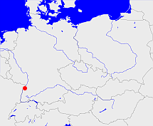
Diese Karte zeigt die Position oder den Umriss des Objekts. Haben Sie einen Fehler entdeckt? Dann würden wir uns über eine Nachricht freuen.
Bemerkungen
Amtssitz: Bühl, Baden, heißt auch Oberamt Yberg oder Bühl
Übergeordnete Objekte
Legende
| | politische Verwaltung |
| | kirchliche Verwaltung |
| | gerichtliche Verwaltung |
| | Wohnplatz |
| | geographische Typen |
| | Verkehrswesen |
Übergeordnete Objekte
Übergeordnete Objekte
Untergeordnete Objekte
| Name |
Typ |
GOV-Kennung |
Zeitraum |
| Liehenbach |
Weiler
|
LIEACHJN48CQ |
(1803 - 1807) |
| Rittersbach, Riedersbach |
Hof
Ortsteil
|
RITACHJN48BQ |
(1803 - 1807) |
| Winzhurst |
Höfe
Wüstung
|
object_407698 |
(1803 - 1807) |
| Hundsbach |
Dorf
Ortsteil
|
HUNACHJN48DO |
(1803 - 1807) |
| Stollhofen, Stollhofen Rheinmünster |
Stadt
Gemeinde
Ortsteil
|
STOFENJN48AS |
(1803 - 1807) |
| Blättich |
Häuser
|
object_407862 |
(1803 - 1807) |
| Gebersberg |
Wohnplatz
|
GEBERGJN48BP |
(1803 - 1807) |
| Bühlertal |
Pfarrdorf
Gemeinde
|
BUHTALJN48CQ |
(1803 - 1807) |
| Herrenwies |
Pfarrdorf
Ortsteil
|
HERIES_W7564 |
(1803 - 1807) |
| Oberbruch, Oberbruch Bühl |
Weiler
Gemeinde
Stadtteil
|
OBEUCHJN48BR |
(1803 - 1807) |
| Unzhurst, Unzhurst Ottersweier |
Dorf
Gemeinde
Ortsteil
|
UNZRSTJN48AQ |
(1803 - 1807) |
| Greffern, Greffern Rheinmünster |
Dorf
Gemeinde
Ortsteil
|
GREERNJN48AS |
(1803 - 1807) |
| Leiberstung, Leberstung Sinzheim |
Pfarrdorf
Gemeinde
Ortschaft
|
LEIUNGJN48BS |
(1803 - 1807) |
| Sasbach |
Gerichtsbezirk
|
object_407860 |
(1803 - 1807) |
| Sasbachried, Ried |
Dorf
Gemeinde
Stadtteil
|
SASIED_W7591 |
(1803 - 1807) |
| Obersasbach, Obersasbach Sasbach |
Dorf
Gemeinde
Ortschaft
|
OBEACHJN48BO |
(1803 - 1807) |
| Bühl |
Gemeinde
Stadt
|
object_1077432 |
(1803 - 1807) |
| Zell |
Weiler
Ortsteil
|
ZELELLJN48AQ |
(1803 - 1807) |
| Waldmatt |
Dorf
Ortsteil
|
WALATTJN48BQ |
(1803 - 1807) |
| Waldsteg |
Ortsteil
|
WALTEGJN48BP |
(1803 - 1807) |
| Großweier, Croschweier |
Pfarrdorf
Gemeinde
Stadtteil
|
GROIER_W7591 |
(1803 - 1807) |
| Henkhurst |
Höfe
Wüstung
|
object_407699 |
(1803 - 1807) |
| Oberweier, Oberweier Bühl |
Weiler
Gemeinde
Stadtteil
|
OBEIERJN48BQ |
(1803 - 1807) |
| Ulm, Ulm Lichtenau |
Dorf
Gemeinde
Ortsteil
|
ULMULMJN48AR |
(1803 - 1807) |
| Stollhofen und Schwarzach |
Amt
Oberamt
|
object_1090476 |
(1803 - 1807) |
| Neusatz, Neusatz Bühl |
Gemeinde
Ortschaft
|
NEUATZJN48BP |
(1803 - 1807) |
| Schwarzach, Schwarzach Rheinmünster |
Flecken
Gemeinde
Ortsteil
|
SCHACHJN48AR |
(1803 - 1807) |
| Büchelbach |
Häuser
Ortsteil
|
BUCACHJN48CQ |
(1803 - 1807) |
| Sasbachwalden |
Gemeinde
|
SASDEN_W7595 |
(1803 - 1807) |
| Moos, Moos Bühl |
Dorf
Gemeinde
Stadtteil
|
MOOOOSJN48AR |
(1803 - 1807) |
| Hesselbach |
Weiler
|
HESACHJN48AP |
(1803 - 1807) |
| Balzhofen Bühl |
Dorf
Gemeinde
Stadtteil
|
BALFENJN48BQ |
(1803 - 1807) |
| Vimbuch, Vimbuch Bühl |
Pfarrdorf
Gemeinde
Ortsteil
|
VIMUCHJN48BR |
(1803 - 1807) |
| Altschweier, Altschweier Bühl |
Gemeinde
Ortsteil
|
ALTIERJN48BQ |
(1803 - 1807) |
| Kappelwindeck |
Pfarrdorf
Ortsteil
|
KAPECKJN48BQ |
(1803 - 1807) |
| Steckenhalt |
Weiler
Ortsteil
|
STEALTJN48CQ |
(1803 - 1807) |
| Hildmannsfeld |
Weiler
Ortsteil
|
HILELDJN48AR |
(1803 - 1807) |
| Sasbach in der Ortenau |
Pfarrdorf
Gemeinde
|
SASACHJN48BP |
(1803 - 1807) |
| Breithurst |
Weiler
Ortsteil
|
BRERSTJN48AQ |
(1803 - 1807) |
| Oberwasser |
Dorf
Ortsteil
|
OBESERJN48AQ |
(1803 - 1807) |
Bilder im GenWiki
Quicktext
object_406826
	 TEXT: Amtssitz: Bühl, Baden, heißt auch Oberamt Yberg oder Bühl:TEXT,
	gehört ab 1771 bis 1803 zu object_1079604,
	gehört ab 1803 bis 1807 zu object_406825,
	heißt  (auf deu) Yberg,
	ist ab 1748 bis 1807 (auf deu) Oberamt;

