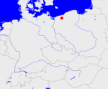
Arnhausen, Lipie

Diese Karte zeigt die Position oder den Umriss des Objekts. Haben Sie einen Fehler entdeckt? Dann würden wir uns über eine Nachricht freuen.
Bemerkungen
Status 1906 - Landgemeinde und Gutsbezirk
Übergeordnete Objekte
Legende
| | politische Verwaltung |
| | kirchliche Verwaltung |
| | gerichtliche Verwaltung |
| | Wohnplatz |
| | geographische Typen |
| | Verkehrswesen |
Übergeordnete Objekte
-
Belgard
(KreisLandkreis) (- 1945)
-
Köslin
(Regierungsbezirk) (1816 - 1945)
-
Rąbino
(Landgemeinde PL) (1999 -)
-
Powiat świdwiński
(Landkreis) (1999 -)
-
Województwo zachodniopomorskie
(Wojewodschaft) (1999 -)
-
Polen (Dritte Republik), Polen, Polaca - Tercera República, Третья Речь Посполитая, La Pologne - IIIe République, Poland (Third Republic), Polska - III Rzeczpospolita
(Republik) (1999 -)
-
Europäische Wirtschaftsgemeinschaft, Europäische Gemeinschaft, Europäische Union, Comhphobal Eacnamaíochta na hEorpa, Euroopan talousyhteisö, Európske hospodárske spoločenstvo, Communauté économique européenne, Comunidad Económica Europea, European Economic Community, Comunità Economica Europea, Evropské hospodářské společenství, Europese Economische Gemeenschap, Európske spoločenstvo, Europese Gemeenschap, Euroopan Yhteisö, Comunidad Europea, European Community, Comunità Europea, Evropské společenství, Communauté européenne, Comhphobal Eorpach, Europese Unie, Aontais Eorpaigh, Unione Europea, European Union, Európska únia, Unión Europea, Euroopan Unioni, Evropská unie, Union européenne
(Staatenbund) (2004 -)
-
Vereinte Nationen, Verenigde Naties, Организация Объединённых Наций, Organización de las Naciones Unidas, Organisation des Nations unies, الأمم المتحدة, 联合国, Organizácia Spojených národov, United Nations
(Staatenbund) (1990 -)
Übergeordnete Objekte
Untergeordnete Objekte
| Name |
Typ |
GOV-Kennung |
Zeitraum |
| Arnhausen |
Kirche
|
object_162926 |
|
Bilder im GenWiki
Quicktext
ARNSE2JO73XT
	 TEXT: Status 1906 - Landgemeinde und Gutsbezirk :TEXT,
	gehört ab 1999 zu object_1074175 sagt source_1079298,
	gehört bis 1945 zu object_214300 sagt source_271893,
	hat externe Kennung  SIMC:310367,
	heißt  (auf deu) Arnhausen sagt source_271893 (Gutsbezirk 2.77) sagt source_271893 (Landgemeinde 2.6),
	heißt ab 1945  (auf pol) Lipie sagt source_149286,
	ist (auf deu) Dorf,
	liegt bei 53.8328°N 15.9389°O;

