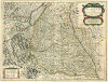
Südlicher Oberrhein
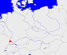
Diese Karte zeigt die Position oder den Umriss des Objekts. Haben Sie einen Fehler entdeckt? Dann würden wir uns über eine Nachricht freuen.
Übergeordnete Objekte
Legende
| | politische Verwaltung |
| | kirchliche Verwaltung |
| | gerichtliche Verwaltung |
| | Wohnplatz |
| | geographische Typen |
| | Verkehrswesen |
Übergeordnete Objekte
-
Freiburg
(Regierungsbezirk) (1973-01-01 -)
-
Baden-Württemberg
(Bundesland) (1973-01-01 -)
-
Deutschland, Bundesrepublik Deutschland, Allemagne, Duitsland, Vokietija, Niemcy, Nemecká spolková republika, Federal Republic of Germany, Tyskland, Germany, Герма́ния
(Bundesstaat) (1952-04-25 -)
-
Europäische Wirtschaftsgemeinschaft, Europäische Gemeinschaft, Europäische Union, Comhphobal Eacnamaíochta na hEorpa, Euroopan talousyhteisö, Európske hospodárske spoločenstvo, Communauté économique européenne, Comunidad Económica Europea, European Economic Community, Comunità Economica Europea, Evropské hospodářské společenství, Europese Economische Gemeenschap, Európske spoločenstvo, Europese Gemeenschap, Euroopan Yhteisö, Comunidad Europea, European Community, Comunità Europea, Evropské společenství, Communauté européenne, Comhphobal Eorpach, Europese Unie, Aontais Eorpaigh, Unione Europea, European Union, Európska únia, Unión Europea, Euroopan Unioni, Evropská unie, Union européenne
(Staatenbund) (1958 -)
-
Vereinte Nationen, Verenigde Naties, Организация Объединённых Наций, Organización de las Naciones Unidas, Organisation des Nations unies, الأمم المتحدة, 联合国, Organizácia Spojených národov, United Nations
(Staatenbund) (1973-09-18 -)
Übergeordnete Objekte
| Name |
Zeitraum |
Typ |
Quelle |
|
Freiburg
|
(1973-01-01 -) |
Regierungsbezirk
|
|
Untergeordnete Objekte
Bilder im GenWiki
Quicktext
object_394071
	gehört ab 1973-01-01 zu adm_369083,
	hat URL  http://www.region-suedlicher-oberrhein.de/,
	hat externe Kennung  leobw:7702,
	heißt  (auf deu) Südlicher Oberrhein,
	ist ab 1973 (auf deu) Region (Gebietskörperschaft);