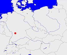
Main und Tauberkreis
Diese Karte zeigt die Position oder den Umriss des Objekts. Haben Sie einen Fehler entdeckt? Dann würden wir uns über eine Nachricht freuen.
Bemerkungen
1810 hervorgegangen aus der Provinz des Unterrrheins
Sitz des Kreisesin Wertheim
1832 im Unterrheinkreis aufgegangen
Übergeordnete Objekte
Legende
| | politische Verwaltung |
| | kirchliche Verwaltung |
| | gerichtliche Verwaltung |
| | Wohnplatz |
| | geographische Typen |
| | Verkehrswesen |
Übergeordnete Objekte
-
Baden
(KurfürstentumGroßherzogtumFreistaat) (1810-01-01 - 1832-02-17)
Übergeordnete Objekte
| Name |
Zeitraum |
Typ |
Quelle |
|
Baden
|
(1810-01-01 - 1832-02-17) |
Kurfürstentum
Großherzogtum
Freistaat
|
|
Untergeordnete Objekte
| Name |
Typ |
GOV-Kennung |
Zeitraum |
| Krautheim |
Amt
|
object_353314 |
(1810-01-01 - 1832-02-17) |
| Wertheim Stadt- und Erstes Landamt |
Amt
|
object_1352005 |
(1813-07-30 - 1819) |
| Osterburken, Adelsheim |
Amt
Bezirksamt
|
object_320493 |
(1810-01-01 - 1832-02-17) |
| Heubach |
Amt
|
object_1086798 |
(1810-01-01 - 1810-12-03) |
| Billigheim |
Amt
|
object_306796 |
(1810-01-01 - 1813-07-29) |
| Amorbach |
Amt
|
object_353167 |
(1810-01-01 - 1810-12-03) |
| Wertheim, Wertheim Zweites Landamt |
Amt
Bezirksamt
|
object_320499 |
(1810-01-01 - 1832-02-17) |
| Miltenberg |
Amt
|
object_884458 |
(1810-01-01 - 1817) |
| Rothenfels |
Amt
|
object_884525 |
(1810-01-01 - 1813-07-29) |
| Tauberbischofsheim |
Amt
|
object_1351545 |
(1810-01-01 - 1832-02-17) |
| Freudenberg |
Amt
|
object_884527 |
(1810-01-01 - 1813-07-29) |
| Rosenberg |
Amt
|
object_884526 |
(1810-01-01 - 1813-07-29) |
| Lauda |
Amt
|
object_1352012 |
(1810-01-01 - 1813-07-29) |
| Mudau |
Amt
|
object_353169 |
(1810-01-01 - 1813-07-29) |
| Walldürn |
Amt
Bezirksamt
|
object_391265 |
(1810-01-01 - 1832-02-17) |
| Grünsfeld |
Amt
|
object_884443 |
(1810-01-01 - 1813-07-29) |
| Külsheim |
Amt
|
object_1352007 |
(1810-01-01 - 1813-07-29) |
| Neudenau |
Amt
|
object_353318 |
(1810-01-01 - 1813-07-29) |
| Boxberg |
Amt
Bezirksamt
Bezirksamt
|
object_320494 |
(1813-07-30 - 1832-02-17) |
| Buchen |
Amt
|
object_884510 |
(1810-01-01 - 1832-02-17) |
| Lohrbach |
Amt
|
object_1352013 |
(1810-01-01 - 1813-07-29) |
Bilder im GenWiki
Quicktext
object_396149
	 TEXT:1810 hervorgegangen aus der Provinz des Unterrrheins
 Sitz des Kreisesin Wertheim
 1832 im Unterrheinkreis aufgegangen :TEXT,
	gehört ab 1810-01-01 bis 1832-02-17 zu object_217952,
	heißt  (auf deu) Main und Tauberkreis,
	ist ab 1810 bis 1832 (auf deu) Kreis (mittlere Verwaltungsebene) sagt source_396146;

