Neuenhaus

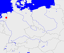
Diese Karte zeigt die Position oder den Umriss des Objekts. Haben Sie einen Fehler entdeckt? Dann würden wir uns über eine Nachricht freuen.
Übergeordnete Objekte
Legende
| | politische Verwaltung |
| | kirchliche Verwaltung |
| | gerichtliche Verwaltung |
| | Wohnplatz |
| | geographische Typen |
| | Verkehrswesen |
Übergeordnete Objekte
-
Bentheim, Grafschaft Bentheim
(HerrschaftGrafschaftLandesteil) (1824 - 1866)
-
Osnabrück
(Landdrostei) (1816 - 1866)
-
Hannover
(KönigreichProvinzLand) (1816 - 1885)
-
Hannover
(KönigreichProvinzLand) (1815 - 1816)
-
Niederländisch-Westfälischer Reichskreis, Westfälischer Reichskreis, Niederrheinisch-Westfälischer Reichskreis
(Reichskreis) (1500 - 1806)
-
Heiliges Römisches Reich, Heiliges Römisches Reich deutscher Nation, Heiliges Römisches Reich, Sacrum Imperium, Sacrum Romanum Imperium, Sacrum Romanum Imperium Nationis Germanicæ
(KönigreichKaiserreich) (- 1500)
-
Steinfurt
(arrondissementBezirk) (1806 - 1809)
-
Lippe, Lippe
(Departement) (1811-04-28 - 1813)
-
Frankreich, France, France, Frankrijk
(KönigreichRepublikKaiserreichKönigreichKaiserreichKönigreichRepublikKaiserreichRepublikStaatRepublik) (1811 - 1814)
-
Vereinte Nationen, Verenigde Naties, Организация Объединённых Наций, Organización de las Naciones Unidas, Organisation des Nations unies, الأمم المتحدة, 联合国, Organizácia Spojených národov, United Nations
(Staatenbund) (1945-10-24 -)
-
Europäische Wirtschaftsgemeinschaft, Europäische Gemeinschaft, Europäische Union, Comhphobal Eacnamaíochta na hEorpa, Euroopan talousyhteisö, Európske hospodárske spoločenstvo, Communauté économique européenne, Comunidad Económica Europea, European Economic Community, Comunità Economica Europea, Evropské hospodářské společenství, Europese Economische Gemeenschap, Európske spoločenstvo, Europese Gemeenschap, Euroopan Yhteisö, Comunidad Europea, European Community, Comunità Europea, Evropské společenství, Communauté européenne, Comhphobal Eorpach, Europese Unie, Aontais Eorpaigh, Unione Europea, European Union, Európska únia, Unión Europea, Euroopan Unioni, Evropská unie, Union européenne
(Staatenbund) (1958 -)
-
IJsselmündungen, Monden van de IJssel, Bouches de l'Yssel
(Departement) (1811-01-01 - 1811-04-27)
-
Frankreich, France, France, Frankrijk
(KönigreichRepublikKaiserreichKönigreichKaiserreichKönigreichRepublikKaiserreichRepublikStaatRepublik) (1811 - 1814)
-
Vereinte Nationen, Verenigde Naties, Организация Объединённых Наций, Organización de las Naciones Unidas, Organisation des Nations unies, الأمم المتحدة, 联合国, Organizácia Spojených národov, United Nations
(Staatenbund) (1945-10-24 -)
-
Europäische Wirtschaftsgemeinschaft, Europäische Gemeinschaft, Europäische Union, Comhphobal Eacnamaíochta na hEorpa, Euroopan talousyhteisö, Európske hospodárske spoločenstvo, Communauté économique européenne, Comunidad Económica Europea, European Economic Community, Comunità Economica Europea, Evropské hospodářské společenství, Europese Economische Gemeenschap, Európske spoločenstvo, Europese Gemeenschap, Euroopan Yhteisö, Comunidad Europea, European Community, Comunità Europea, Evropské společenství, Communauté européenne, Comhphobal Eorpach, Europese Unie, Aontais Eorpaigh, Unione Europea, European Union, Európska únia, Unión Europea, Euroopan Unioni, Evropská unie, Union européenne
(Staatenbund) (1958 -)
-
Berg, Grand-Duché de Berg
(Großherzogtum) (1806 - 1809)
-
Neuenhaus
(Amtsgericht) (1852 -)
-
Königlich-Hannoversches und Herzoglich-Arenberg'sches Gesammt-Obergericht Meppen
(Landgericht) (1852 - 1875)
-
Ober-Appellationsgericht Celle, Celle
(Oberlandesgericht) (1852 - 1875)
-
Niedersachsen, Neder-Saksen, Lower Saxony
(LandBundesland) (1946-11-01 -)
-
Deutschland, Bundesrepublik Deutschland, Allemagne, Duitsland, Vokietija, Niemcy, Nemecká spolková republika, Federal Republic of Germany, Tyskland, Germany, Герма́ния
(Staat) (1949-05-24 -)
-
Europäische Wirtschaftsgemeinschaft, Europäische Gemeinschaft, Europäische Union, Comhphobal Eacnamaíochta na hEorpa, Euroopan talousyhteisö, Európske hospodárske spoločenstvo, Communauté économique européenne, Comunidad Económica Europea, European Economic Community, Comunità Economica Europea, Evropské hospodářské společenství, Europese Economische Gemeenschap, Európske spoločenstvo, Europese Gemeenschap, Euroopan Yhteisö, Comunidad Europea, European Community, Comunità Europea, Evropské společenství, Communauté européenne, Comhphobal Eorpach, Europese Unie, Aontais Eorpaigh, Unione Europea, European Union, Európska únia, Unión Europea, Euroopan Unioni, Evropská unie, Union européenne
(Staatenbund) (1958 -)
-
Vereinte Nationen, Verenigde Naties, Организация Объединённых Наций, Organización de las Naciones Unidas, Organisation des Nations unies, الأمم المتحدة, 联合国, Organizácia Spojených národov, United Nations
(Staatenbund) (1973-09-18 -)
-
Britische Besatzungszone
(Besatzungszone) (1946-11-01 - 1949-05-23)
-
Reichsgericht
(Oberstes Gericht) (1879-10-01 - 1945-05-08)
-
Hannover
(KönigreichProvinzLand) (- 1946-11-01)
-
Bundesgerichtshof
(Oberstes Gericht) (1950-10-01 -)
-
Obergericht Osnabrück, Osnabrück
(Landgericht) (1875 - 1973)
-
Ober-Appellationsgericht Celle, Celle
(Oberlandesgericht) (- 1944)
-
Niedersachsen, Neder-Saksen, Lower Saxony
(LandBundesland) (1946-11-01 -)
-
Deutschland, Bundesrepublik Deutschland, Allemagne, Duitsland, Vokietija, Niemcy, Nemecká spolková republika, Federal Republic of Germany, Tyskland, Germany, Герма́ния
(Staat) (1949-05-24 -)
-
Europäische Wirtschaftsgemeinschaft, Europäische Gemeinschaft, Europäische Union, Comhphobal Eacnamaíochta na hEorpa, Euroopan talousyhteisö, Európske hospodárske spoločenstvo, Communauté économique européenne, Comunidad Económica Europea, European Economic Community, Comunità Economica Europea, Evropské hospodářské společenství, Europese Economische Gemeenschap, Európske spoločenstvo, Europese Gemeenschap, Euroopan Yhteisö, Comunidad Europea, European Community, Comunità Europea, Evropské společenství, Communauté européenne, Comhphobal Eorpach, Europese Unie, Aontais Eorpaigh, Unione Europea, European Union, Európska únia, Unión Europea, Euroopan Unioni, Evropská unie, Union européenne
(Staatenbund) (1958 -)
-
Vereinte Nationen, Verenigde Naties, Организация Объединённых Наций, Organización de las Naciones Unidas, Organisation des Nations unies, الأمم المتحدة, 联合国, Organizácia Spojených národov, United Nations
(Staatenbund) (1973-09-18 -)
-
Britische Besatzungszone
(Besatzungszone) (1946-11-01 - 1949-05-23)
-
Reichsgericht
(Oberstes Gericht) (1879-10-01 - 1945-05-08)
-
Hannover
(KönigreichProvinzLand) (- 1946-11-01)
-
Bundesgerichtshof
(Oberstes Gericht) (1950-10-01 -)
-
Oldenburg
(Oberlandesgericht) (1944 -)
-
Bundesgerichtshof
(Oberstes Gericht) (1950-10-01 -)
-
Niedersachsen, Neder-Saksen, Lower Saxony
(LandBundesland) (1946 -)
-
Deutschland, Bundesrepublik Deutschland, Allemagne, Duitsland, Vokietija, Niemcy, Nemecká spolková republika, Federal Republic of Germany, Tyskland, Germany, Герма́ния
(Staat) (1949-05-24 -)
-
Europäische Wirtschaftsgemeinschaft, Europäische Gemeinschaft, Europäische Union, Comhphobal Eacnamaíochta na hEorpa, Euroopan talousyhteisö, Európske hospodárske spoločenstvo, Communauté économique européenne, Comunidad Económica Europea, European Economic Community, Comunità Economica Europea, Evropské hospodářské společenství, Europese Economische Gemeenschap, Európske spoločenstvo, Europese Gemeenschap, Euroopan Yhteisö, Comunidad Europea, European Community, Comunità Europea, Evropské společenství, Communauté européenne, Comhphobal Eorpach, Europese Unie, Aontais Eorpaigh, Unione Europea, European Union, Európska únia, Unión Europea, Euroopan Unioni, Evropská unie, Union européenne
(Staatenbund) (1958 -)
-
Vereinte Nationen, Verenigde Naties, Организация Объединённых Наций, Organización de las Naciones Unidas, Organisation des Nations unies, الأمم المتحدة, 联合国, Organizácia Spojených národov, United Nations
(Staatenbund) (1973-09-18 -)
-
Britische Besatzungszone
(Besatzungszone) (1946-11-01 - 1949-05-23)
-
Reichsgericht
(Oberstes Gericht) (1879-10-01 - 1945-05-08)
-
Osnabrück
(Landdrostei) (1866 - 1885)
-
Hannover
(KönigreichProvinzLand) (1816 - 1885)
Übergeordnete Objekte
Untergeordnete Objekte
| Name |
Typ |
GOV-Kennung |
Zeitraum |
| Hesepe |
Gemeinde
|
HESEPEJO32NJ |
(1824 - 1885) |
| Hilten |
Gemeinde
|
HILTENJO32LL |
(1824 - 1885) |
| Veldgaar |
Gemeinde
|
VELAARJO32LM |
(1824 - 1885) |
| Vorwald |
Gemeinde
|
VORALDJO32JO |
(1824 - 1885) |
| Arkel, Hoogstede |
Standesamt
|
object_1151039 |
(1874 - 1885) |
| Georgsdorf |
Standesamt
|
object_1154956 |
(1874 - 1885) |
| Kleinringe |
Gemeinde
|
KLENGEJO32KO |
(1824 - 1885) |
| Uelsen |
Standesamt
|
object_1153331 |
(1874 - 1885) |
| Volzel |
Gemeinde
|
VOLZELJO32JO |
(1824 - 1885) |
| Wielen |
Gemeinde
|
WIELENJO32IN |
(1824 - 1885) |
| Wilsum |
Standesamt
|
object_1151945 |
(1874 - 1885) |
| Wilsum |
Gemeinde
|
WILSUMJO32KM |
(1824 - 1885) |
| Heesterkante |
Gemeinde
|
HEENTEJO32IO |
(1824 - 1885) |
| Hohenkörben (Kirchspiel Nordhorn) |
Gemeinde
|
HOHORNJO32NM |
(1824 - 1885) |
| Thesingfeld |
Gemeinde
|
THEELDJO32LL |
(1824 - 1885) |
| Bischopspool, Bischofspool |
Gemeinde
|
BISOOLJO32LM |
(1824 - 1885) |
| Veldhausen |
Standesamt
|
object_1151943 |
(1874 - 1885) |
| Alte Piccardie |
Gemeinde
|
ALTDIEJO32MN |
(1824 - 1885) |
| Neue Piccardie, Georgsdorf |
Gemeinde
|
GEOORFJO32MN |
(1824 - 1885) |
| Bookholt, Bockholt |
Gemeinde
|
BOOOLTJO32ML |
(1824 - 1885) |
| Großringe |
Gemeinde
|
GRONGEJO32LO |
(1824 - 1885) |
| Binnenborg |
Gemeinde
|
BINORGJO32LM |
(1824 - 1885) |
| Hoostede, Hochstädte, Hoogstede-Bathorn, Hoogstede |
Gemeinde
|
HOOEDEJO32LO |
(1824 - 1885) |
| Hesingen |
Gemeinde
|
object_1175776 |
(1824 - 1885) |
| Laar, Laer |
Gemeinde
|
LAAAAR_W4459 |
(1824 - 1885) |
| Haftenkamp |
Gemeinde
|
HAFAMPJO32LM |
(1824 - 1885) |
| Striepe |
Gemeinde
|
object_1175777 |
(1824 - 1885) |
| Gölenkamp |
Gemeinde
|
GOLAMP_W4459 |
(1824 - 1885) |
| Eschebrügge |
Gemeinde
|
ESCGGEJO32JP |
(1824 - 1885) |
| Laar |
Standesamt
|
object_1151946 |
(1874 - 1885) |
| Lage |
Standesamt
|
object_1149236 |
(1874 - 1885) |
| Lage |
Gemeinde
|
LAGAGE_W4458 |
(1824 - 1885) |
| Adorf |
Gemeinde
|
ADOORFJO32NO |
(1824 - 1885) |
| Berge |
Gemeinde
|
BERRG1JO32LN |
(1824 - 1885) |
| Esche |
Gemeinde
|
ESCCHE_W4458 |
(1824 - 1885) |
| Halle |
Gemeinde
|
HALLLEJO32LK |
(1824 - 1885) |
| Kalle |
Gemeinde
|
KALLLEJO32LN |
(1824 - 1885) |
| Lemke |
Gemeinde
|
LEMMKEJO32KL |
(1824 - 1885) |
| Buitenborg |
Gemeinde
|
BUIORGJO32LM |
(1824 - 1885) |
| Itterbeck |
Gemeinde
|
ITTECKJO32JM |
(1824 - 1885) |
| Teich |
Gemeinde
|
NEUAU1JO32LL |
(1824 - 1885) |
| Neuenhaus |
Standesamt
|
object_1151944 |
(1874 - 1885) |
| Grasdorf |
Gemeinde
|
GRAORFJO32LL |
(1824 - 1885) |
| Tinholt |
Gemeinde
|
TINOLTJO32LN |
(1824 - 1885) |
| Osterwald |
Gemeinde
|
OSTALDJO32MN |
(1824 - 1885) |
| Agterhorn |
Gemeinde
|
AGTORNJO32JO |
(1824 - 1885) |
| Neuenhaus, Nyenhus, Nieuwenhuis |
Stadt
|
NEUAUSJO32LM |
(1824 - 1885) |
| Altendorf |
Gemeinde
|
ALTORFJO32NK |
(1824 - 1885) |
| Hardinghausen |
Gemeinde
|
HARSENJO32KM |
(1824 - 1885) |
| Echteler |
Gemeinde
|
ECHLERJO32JO |
(1824 - 1885) |
| Emlichheim |
Standesamt
|
object_1149902 |
(1874 - 1885) |
| Emlichheim |
Gemeinde
|
EMLEIM_W4459 |
(1824 - 1885) |
| Bimolten |
Gemeinde
|
BIMTENJO32ML |
(1824 - 1885) |
| Uelsen, Ulzen |
Flecken
Gemeinde
|
UELSENJO32KM |
(1824 - 1885) |
| Wietmarschen |
Standesamt
|
object_1149234 |
(1874 - 1885) |
| Wietmarschen |
Gemeinde
|
WIEHENJO32NM |
(1824 - 1885) |
| Hardingen |
Gemeinde
|
HARGENJO32LL |
(1824 - 1885) |
| Bakelde |
Gemeinde
|
BAKLDEJO32NK |
(1824 - 1885) |
| Scheerhorn |
Gemeinde
|
SCHORNJO32LN |
(1824 - 1885) |
| Bathorn |
Gemeinde
|
BATORNJO32LN |
(1824 - 1885) |
| Neuringe |
Standesamt
|
object_1149235 |
(1874 - 1885) |
| Neuringe |
Gemeinde
|
NEUNGEJO32MP |
(1824 - 1885) |
| Frenswegen |
Gutsbezirk
|
object_1139031 |
(1824 - 1885) |
| Hohenkörben (Kirchspiel Veldhausen) |
Gemeinde
|
HOHSENJO32MM |
(1824 - 1885) |
| Balderhaar |
Gemeinde
|
object_1175775 |
(1824 - 1885) |
| Nordhorn |
Standesamt
|
object_1154082 |
(1874 - 1885) |
| Nordhorn |
Stadt
|
NORORNJO32MK |
(1824 - 1885) |
| Höcklenkamp |
Gemeinde
|
HOCAMPJO32KL |
(1824 - 1885) |
| Veldhausen, Veldhuizen |
Gemeinde
|
VELSENJO32LM |
(1824 - 1885) |
| Bauerhausen, Bauer- und Sandhäuser |
Gemeinde
|
BAUSENJO32KM |
(1824 - 1885) |
| Frensdorf |
Gemeinde
|
FREORFJO32MK |
(1824 - 1885) |
| Brecklenkamp |
Gemeinde
|
BREAM1JO32LK |
(1824 - 1885) |
| Getelo |
Gemeinde
|
GETELO_W4459 |
(1824 - 1885) |
Bilder im GenWiki
Quicktext
object_406565
	gehört ab 1824 bis 1866 zu object_406716,
	gehört ab 1852 zu object_285923,
	gehört ab 1866 bis 1885 zu object_810430,
	hat 1852 Einwohner 18568 sagt source_356847,
	heißt  (auf deu) Neuenhaus,
	ist ab 1824 bis 1885 (auf deu) Amt (kreisähnlich);


