Vaals

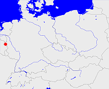
Diese Karte zeigt die Position oder den Umriss des Objekts. Haben Sie einen Fehler entdeckt? Dann würden wir uns über eine Nachricht freuen.
Übergeordnete Objekte
Legende
| | politische Verwaltung |
| | kirchliche Verwaltung |
| | gerichtliche Verwaltung |
| | Wohnplatz |
| | geographische Typen |
| | Verkehrswesen |
Übergeordnete Objekte
- Limburg (Herzogtum)
- Nederlands-Limburg, Limburg, Limburg (Provinz)
- Niederlande, Batavische Republik, Königreich Holland, Vereinigtes Königreich der Niederlande, Нидерланды, Pays-Bas, Países Bajos, Netherlands, Nederland, The Netherlands, Republiek der Zeven Verenigde Provinciën, Bataafse Republiek, Koninkrijk Holland, Verenigd Koninkrijk der Nederlanden (Republik Königreich Staat)
- Königreich der Niederlande, le royaume des Pays-Bas, Kingdom of the Netherlands, Koninkrijk der Nederlanden (Königreich)
- Europäische Wirtschaftsgemeinschaft, Europäische Gemeinschaft, Europäische Union, Comhphobal Eacnamaíochta na hEorpa, Euroopan talousyhteisö, Európske hospodárske spoločenstvo, Communauté économique européenne, Comunidad Económica Europea, European Economic Community, Evropské hospodářské společenství, Europese Economische Gemeenschap, Comunità Economica Europea, Európske spoločenstvo, Europese Gemeenschap, Euroopan Yhteisö, European Community, Evropské společenství, Communauté européenne, Comhphobal Eorpach, Comunidad Europea, Comunità Europea, Európska únia, Europese Unie, Aontais Eorpaigh, European Union, Unión Europea, Euroopan Unioni, Evropská unie, Union européenne, Unione Europea (Staatenbund)
- Limburg (Provinz)
- Niederlande, Batavische Republik, Königreich Holland, Vereinigtes Königreich der Niederlande, Нидерланды, Pays-Bas, Países Bajos, Netherlands, Nederland, The Netherlands, Republiek der Zeven Verenigde Provinciën, Bataafse Republiek, Koninkrijk Holland, Verenigd Koninkrijk der Nederlanden (Republik Königreich Staat)
- Königreich der Niederlande, le royaume des Pays-Bas, Kingdom of the Netherlands, Koninkrijk der Nederlanden (Königreich)
- Europäische Wirtschaftsgemeinschaft, Europäische Gemeinschaft, Europäische Union, Comhphobal Eacnamaíochta na hEorpa, Euroopan talousyhteisö, Európske hospodárske spoločenstvo, Communauté économique européenne, Comunidad Económica Europea, European Economic Community, Evropské hospodářské společenství, Europese Economische Gemeenschap, Comunità Economica Europea, Európske spoločenstvo, Europese Gemeenschap, Euroopan Yhteisö, European Community, Evropské společenství, Communauté européenne, Comhphobal Eorpach, Comunidad Europea, Comunità Europea, Európska únia, Europese Unie, Aontais Eorpaigh, European Union, Unión Europea, Euroopan Unioni, Evropská unie, Union européenne, Unione Europea (Staatenbund)
- Belgien, Belgique, België, Belgium, Бельгия (Königreich)
- Europäische Wirtschaftsgemeinschaft, Europäische Gemeinschaft, Europäische Union, Comhphobal Eacnamaíochta na hEorpa, Euroopan talousyhteisö, Európske hospodárske spoločenstvo, Communauté économique européenne, Comunidad Económica Europea, European Economic Community, Evropské hospodářské společenství, Europese Economische Gemeenschap, Comunità Economica Europea, Európske spoločenstvo, Europese Gemeenschap, Euroopan Yhteisö, European Community, Evropské společenství, Communauté européenne, Comhphobal Eorpach, Comunidad Europea, Comunità Europea, Európska únia, Europese Unie, Aontais Eorpaigh, European Union, Unión Europea, Euroopan Unioni, Evropská unie, Union européenne, Unione Europea (Staatenbund)
- Vereinte Nationen, Organización de las Naciones Unidas, Organisation des Nations unies, 联合国, Организация Объединённых Наций, الأمم المتحدة, United Nations, Verenigde Naties, Organizácia Spojených národov (Staatenbund)
Quicktext
GEMALSJO30AS
	 TEXT: Amsterdamse code: 10007; CBS-code: 0981 :TEXT,
	gehört ab 1815 bis 1839 zu object_1329651,
	gehört ab 1839 bis 1866 zu object_1023537,
	gehört ab 1866 zu LIMURGJO31AG,
	hat 2005 Einwohner 10423,
	hat 2006 Einwohner 10068,
	hat URL  http://www.vaals.nl,
	hat externe Kennung  geonames:2745904,
	hat externe Kennung  nima:-2154390,
	heißt  (auf dut) Vaals,
	ist (auf deu) Gemeinde,
	liegt bei 50.7666667°N 6.0166667°O;
