Geradstetten
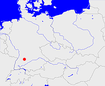
Diese Karte zeigt die Position oder den Umriss des Objekts. Haben Sie einen Fehler entdeckt? Dann würden wir uns über eine Nachricht freuen.
Übergeordnete Objekte
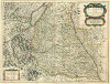
Legende
| | politische Verwaltung |
| | kirchliche Verwaltung |
| | gerichtliche Verwaltung |
| | Wohnplatz |
| | geographische Typen |
| | Verkehrswesen |
Übergeordnete Objekte
- Waiblingen (Landkreis)
- Württemberg, Nordwürttemberg (Landesbezirk Regierungsbezirk)
- Württemberg-Baden (Land Bundesland)
- Deutschland, Bundesrepublik Deutschland, Tyskland, Germany, Allemagne, Vokietija, Герма́ния, Duitsland, Niemcy, Nemecká spolková republika, Federal Republic of Germany (Bundesstaat)
- Europäische Wirtschaftsgemeinschaft, Europäische Gemeinschaft, Europäische Union, Comhphobal Eacnamaíochta na hEorpa, Euroopan talousyhteisö, Európske hospodárske spoločenstvo, Communauté économique européenne, Comunidad Económica Europea, European Economic Community, Evropské hospodářské společenství, Europese Economische Gemeenschap, Comunità Economica Europea, Európske spoločenstvo, Europese Gemeenschap, Euroopan Yhteisö, European Community, Evropské společenství, Communauté européenne, Comhphobal Eorpach, Comunidad Europea, Comunità Europea, Európska únia, Europese Unie, Aontais Eorpaigh, European Union, Unión Europea, Euroopan Unioni, Evropská unie, Union européenne, Unione Europea (Staatenbund)
- Vereinte Nationen, Organización de las Naciones Unidas, Organisation des Nations unies, 联合国, Организация Объединённых Наций, الأمم المتحدة, United Nations, Verenigde Naties, Organizácia Spojených národov (Staatenbund)
- US-Besatzungszone, Amerikanische Besatzungszone, American Zone of Occupation (Besatzungszone)
- Baden-Württemberg (Bundesland)
- Deutschland, Bundesrepublik Deutschland, Tyskland, Germany, Allemagne, Vokietija, Герма́ния, Duitsland, Niemcy, Nemecká spolková republika, Federal Republic of Germany (Bundesstaat)
- Europäische Wirtschaftsgemeinschaft, Europäische Gemeinschaft, Europäische Union, Comhphobal Eacnamaíochta na hEorpa, Euroopan talousyhteisö, Európske hospodárske spoločenstvo, Communauté économique européenne, Comunidad Económica Europea, European Economic Community, Evropské hospodářské společenství, Europese Economische Gemeenschap, Comunità Economica Europea, Európske spoločenstvo, Europese Gemeenschap, Euroopan Yhteisö, European Community, Evropské společenství, Communauté européenne, Comhphobal Eorpach, Comunidad Europea, Comunità Europea, Európska únia, Europese Unie, Aontais Eorpaigh, European Union, Unión Europea, Euroopan Unioni, Evropská unie, Union européenne, Unione Europea (Staatenbund)
- Vereinte Nationen, Organización de las Naciones Unidas, Organisation des Nations unies, 联合国, Организация Объединённых Наций, الأمم المتحدة, United Nations, Verenigde Naties, Organizácia Spojených národov (Staatenbund)
- Volksstaat Württemberg (Republik)
- Deutsches Reich, German Empire, Duitse Rijk (Bundesstaat)
- Völkerbund, Société des Nations, League of Nations, Sociedad de Naciones, Folkeforbundet, 國際聯盟, Liga Narodów, Volkenbond, 国際連盟, Società delle Nazioni, Milletler Cemiyeti, Sociedade das Nações (Staatenbund)
- Rems-Murr-Kreis (Landkreis)
- Stuttgart (Region)
- Stuttgart (Regierungsbezirk)
- Baden-Württemberg (Bundesland)
- Deutschland, Bundesrepublik Deutschland, Tyskland, Germany, Allemagne, Vokietija, Герма́ния, Duitsland, Niemcy, Nemecká spolková republika, Federal Republic of Germany (Bundesstaat)
- Europäische Wirtschaftsgemeinschaft, Europäische Gemeinschaft, Europäische Union, Comhphobal Eacnamaíochta na hEorpa, Euroopan talousyhteisö, Európske hospodárske spoločenstvo, Communauté économique européenne, Comunidad Económica Europea, European Economic Community, Evropské hospodářské společenství, Europese Economische Gemeenschap, Comunità Economica Europea, Európske spoločenstvo, Europese Gemeenschap, Euroopan Yhteisö, European Community, Evropské společenství, Communauté européenne, Comhphobal Eorpach, Comunidad Europea, Comunità Europea, Európska únia, Europese Unie, Aontais Eorpaigh, European Union, Unión Europea, Euroopan Unioni, Evropská unie, Union européenne, Unione Europea (Staatenbund)
- Vereinte Nationen, Organización de las Naciones Unidas, Organisation des Nations unies, 联合国, Организация Объединённых Наций, الأمم المتحدة, United Nations, Verenigde Naties, Organizácia Spojených národov (Staatenbund)
- Remshalden (Gemeinde)
- Rems-Murr-Kreis (Landkreis)
- Stuttgart (Region)
- Stuttgart (Regierungsbezirk)
- Baden-Württemberg (Bundesland)
- Deutschland, Bundesrepublik Deutschland, Tyskland, Germany, Allemagne, Vokietija, Герма́ния, Duitsland, Niemcy, Nemecká spolková republika, Federal Republic of Germany (Bundesstaat)
- Europäische Wirtschaftsgemeinschaft, Europäische Gemeinschaft, Europäische Union, Comhphobal Eacnamaíochta na hEorpa, Euroopan talousyhteisö, Európske hospodárske spoločenstvo, Communauté économique européenne, Comunidad Económica Europea, European Economic Community, Evropské hospodářské společenství, Europese Economische Gemeenschap, Comunità Economica Europea, Európske spoločenstvo, Europese Gemeenschap, Euroopan Yhteisö, European Community, Evropské společenství, Communauté européenne, Comhphobal Eorpach, Comunidad Europea, Comunità Europea, Európska únia, Europese Unie, Aontais Eorpaigh, European Union, Unión Europea, Euroopan Unioni, Evropská unie, Union européenne, Unione Europea (Staatenbund)
- Vereinte Nationen, Organización de las Naciones Unidas, Organisation des Nations unies, 联合国, Организация Объединённых Наций, الأمم المتحدة, United Nations, Verenigde Naties, Organizácia Spojených národov (Staatenbund)
- Schorndorf, Kreis Schorndorf (Oberamt)
- Jagstkreis (Kreis)
- Württemberg (Königreich)
- Rheinbund, Confédération du Rhin (Staatenbund)
- Deutscher Bund, German Confederation (Staatenbund)
- Deutsches Reich, German Empire, Duitse Rijk (Bundesstaat)
- Völkerbund, Société des Nations, League of Nations, Sociedad de Naciones, Folkeforbundet, 國際聯盟, Liga Narodów, Volkenbond, 国際連盟, Società delle Nazioni, Milletler Cemiyeti, Sociedade das Nações (Staatenbund)
- Volksstaat Württemberg (Republik)
- Deutsches Reich, German Empire, Duitse Rijk (Bundesstaat)
- Völkerbund, Société des Nations, League of Nations, Sociedad de Naciones, Folkeforbundet, 國際聯盟, Liga Narodów, Volkenbond, 国際連盟, Società delle Nazioni, Milletler Cemiyeti, Sociedade das Nações (Staatenbund)
- Schorndorf (Elfter Kreis) (Kreis)
- Württemberg (Königreich)
- Rheinbund, Confédération du Rhin (Staatenbund)
- Deutscher Bund, German Confederation (Staatenbund)
- Deutsches Reich, German Empire, Duitse Rijk (Bundesstaat)
- Völkerbund, Société des Nations, League of Nations, Sociedad de Naciones, Folkeforbundet, 國際聯盟, Liga Narodów, Volkenbond, 国際連盟, Società delle Nazioni, Milletler Cemiyeti, Sociedade das Nações (Staatenbund)
- Volksstaat Württemberg (Republik)
- Deutsches Reich, German Empire, Duitse Rijk (Bundesstaat)
- Völkerbund, Société des Nations, League of Nations, Sociedad de Naciones, Folkeforbundet, 國際聯盟, Liga Narodów, Volkenbond, 国際連盟, Società delle Nazioni, Milletler Cemiyeti, Sociedade das Nações (Staatenbund)
- IX. Landvogtei an der Fils und Rems (Kreis)
- Württemberg (Königreich)
- Rheinbund, Confédération du Rhin (Staatenbund)
- Deutscher Bund, German Confederation (Staatenbund)
- Deutsches Reich, German Empire, Duitse Rijk (Bundesstaat)
- Völkerbund, Société des Nations, League of Nations, Sociedad de Naciones, Folkeforbundet, 國際聯盟, Liga Narodów, Volkenbond, 国際連盟, Società delle Nazioni, Milletler Cemiyeti, Sociedade das Nações (Staatenbund)
Übergeordnete Objekte
Untergeordnete Objekte
Quicktext
GERTENJN48RT
	 TEXT:Württemberg erwarb 1506 einen Teil des Ortes und 1687 den zum Ritterkanton gehörenden Rest:TEXT,
	gehört ab 1506 bis 1938 zu object_190778,
	gehört ab 1938 bis 1973 zu object_306665,
	gehört ab 1973 bis 1974 zu adm_138119,
	gehört ab 1974 zu REMDENJN48RT,
	hat ab 1993-07-01 PLZ 73630,
	hat bis 1993-06-30 PLZ W7064,
	heißt  (auf deu) Geradstetten,
	ist ab 1818 bis 1974 (auf deu) Gemeinde,
	ist ab 1974 (auf deu) Ortsteil,
	ist bis 1818 (auf deu) Pfarrdorf,
	liegt bei 48.8°N 9.43°O;