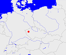
Plasy

Diese Karte zeigt die Position oder den Umriss des Objekts. Haben Sie einen Fehler entdeckt? Dann würden wir uns über eine Nachricht freuen.
Übergeordnete Objekte
Legende
| | politische Verwaltung |
| | kirchliche Verwaltung |
| | gerichtliche Verwaltung |
| | Wohnplatz |
| | geographische Typen |
| | Verkehrswesen |
Übergeordnete Objekte
- Tschechische Republik, Tschechien, République tchèque, Czech Republic, República Checa, Česká republika, Czechia, Tsjechië, Czechia (Czech Republic), Česká socialistická republika (Unionsrepublik Republik)
- Europäische Wirtschaftsgemeinschaft, Europäische Gemeinschaft, Europäische Union, Comhphobal Eacnamaíochta na hEorpa, Euroopan talousyhteisö, Európske hospodárske spoločenstvo, Communauté économique européenne, Comunidad Económica Europea, European Economic Community, Evropské hospodářské společenství, Europese Economische Gemeenschap, Comunità Economica Europea, Európske spoločenstvo, Europese Gemeenschap, Euroopan Yhteisö, European Community, Evropské společenství, Communauté européenne, Comhphobal Eorpach, Comunidad Europea, Comunità Europea, Európska únia, Europese Unie, Aontais Eorpaigh, European Union, Unión Europea, Euroopan Unioni, Evropská unie, Union européenne, Unione Europea (Staatenbund)
- Vereinte Nationen, Organización de las Naciones Unidas, Organisation des Nations unies, 联合国, Организация Объединённых Наций, الأمم المتحدة, United Nations, Verenigde Naties, Organizácia Spojených národov (Staatenbund)
- Tschechoslowakei, Tschecho-Slowakische Republik, Tschechoslowakei, Tschechoslowakische Republik, Tschechoslowakische Sozialistische Republik, Tschechische und Slowakische Föderative Republik, Tschechoslowakei, Československo, Československo, Česko-Slovenská Republika (ČSR), Česko-Slovenská Republika (ČSR), Československo, Československá republika, Czechoslovak Republic, Československá Republika (ČSR), Československá socialistická republika (ČSSR), Česká a Slovenská Federativní Republika (ČSFR), Tsjecho-Slowakije, Tsjechoslowakije, Česká a Slovenská Federatívna Republika (ČSFR) (Republik Republik)
Untergeordnete Objekte
| Name |
Typ |
GOV-Kennung |
Zeitraum |
| Deslawen, Zdeslav |
Gemeinde
|
DESWENJO60SB |
(1950) |
| Hochlibin, Vysoká Libyně, Libyně |
Gemeinde
|
HOCBINJO60RA |
(1950) |
| Scheles, Zihel, Schöla, Schöl, Zyhel, Schöles, Žihle, Žíhle |
Gemeinde
|
SCHLESJO60QB |
(1950) |
| Überbergen, Prehor, Ueberbergen, Přehoř, Přehořov |
Gemeinde
|
PEHEHOJO60QA |
(1950) |
| Neu Walltzisdorf, Neu Neuwallisdorf, Nová Ves |
Gemeinde
|
NEUORFJO60SB |
(1950 -) |
| Manetin, Manětín |
Gemeinde
|
MANNTNJN69OX |
(1950) |
| Rabenstein, Rabštejn nad Střelou |
Gemeinde
|
RABEINJO60PB |
(1950) |
| Trahona, Trhomné |
Gemeinde
|
object_1336553 |
(1950) |
| Ratschin, Radschin, Račín, Račín I. díl |
Gemeinde
|
object_1336555 |
(1950) |
| Unischau, Anischau, Úněšov |
Gemeinde
|
object_1336582 |
(1950) |
| Podmokl, Podmokly |
Gemeinde
|
object_1339146 |
(1950) |
| Cihana, Tschihana, Číhaná |
Gemeinde
|
object_1336581 |
(1950) |
| Mosting, Mostice |
Gemeinde
|
object_1339163 |
(1950) |
| Schwan, Čbán, Švan |
Gemeinde
|
object_1339170 |
(1950) |
Quicktext
object_1324912
	gehört zu object_262328,
	heißt  (auf cze) Plasy,
	ist 1950 (auf deu) Kreis sagt source_1285504;
