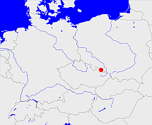
Mocker

Diese Karte zeigt die Position oder den Umriss des Objekts. Haben Sie einen Fehler entdeckt? Dann würden wir uns über eine Nachricht freuen.
Übergeordnete Objekte
Legende
| | politische Verwaltung |
| | kirchliche Verwaltung |
| | gerichtliche Verwaltung |
| | Wohnplatz |
| | geographische Typen |
| | Verkehrswesen |
Übergeordnete Objekte
| Name |
Zeitraum |
Typ |
Quelle |
|
Ratibor
|
|
Kirchenkreis
|
Quelle
S. 270 Nr. 5.5
|
Untergeordnete Objekte
| Name |
Typ |
GOV-Kennung |
Zeitraum |
| Mocker |
Kirche
|
object_173601 |
|
| Roben, Równe |
GemeindeLandgemeinde
|
object_387217 |
(1885) |
| Soppau |
GemeindeLandgemeinde
|
object_387226 |
(1885) |
| Troplowitz, Dorf, Tropplowitz, Dorf Troplowitz |
Landgemeinde
|
object_1266074 |
(1885) |
| Troplowitz, Städtel, Tropplowitz, städtisch, Städtel Troplowitz |
StadtLandgemeinde
|
object_334818 |
(1885) |
| Schönwiese |
GemeindeLandgemeinde
|
object_387225 |
(1885) |
| Moker (hl. Johann v. Nepomuk), Mokre (św. Maksymiliana Kolbe) |
Filiale
|
MOKMUKJO80UD |
(1863) |
| Mocker |
GemeindeLandgemeinde
|
object_387206 |
(1885) |
| Bratsch |
GemeindeLandgemeinde
|
object_387177 |
(1885) |
| Komeise, Comeise |
GemeindeLandgemeinde
|
object_387178 |
(1885) |
| Pilgersdorf |
GemeindeLandgemeinde
|
object_387211 |
(1885) |
Quicktext
object_173600
	gehört zu object_172413 sagt source_394367 (S. 270 Nr. 5.5),
	hat Konfession ev sagt source_394367 (S. 270 Nr. 5.5),
	heißt  (auf deu) Mocker sagt source_394367 (S. 270 Nr. 5.5),
	ist (auf deu) Kirchspiel sagt source_394367 (S. 270 Nr. 5.5);
