Striegau
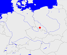
Diese Karte zeigt die Position oder den Umriss des Objekts. Haben Sie einen Fehler entdeckt? Dann würden wir uns über eine Nachricht freuen.
Übergeordnete Objekte
Legende
| | politische Verwaltung |
| | kirchliche Verwaltung |
| | gerichtliche Verwaltung |
| | Wohnplatz |
| | geographische Typen |
| | Verkehrswesen |
Übergeordnete Objekte
Übergeordnete Objekte
| Name |
Zeitraum |
Typ |
Quelle |
|
Breslau
|
(1820 -) |
Regierungsbezirk
|
|
|
Reichenbach
|
(1816 - 1820) |
Regierungsbezirk
|
|
|
Breslau
|
(- 1816) |
Regierungsbezirk
|
|
Untergeordnete Objekte
| Name |
Typ |
GOV-Kennung |
Zeitraum |
| Haidau |
Gemeinde
|
object_1253058 |
(- 1932) |
| Laasan |
Landgemeinde
Gemeinde
|
object_1197410 |
(- 1932-09-30) |
| Laasan |
Amtsbezirk
|
object_1197408 |
(1874-02-28 - 1932-09-30) |
| Laasan |
Gutsbezirk
|
object_322339 |
(- 1928) |
| Muhrau |
Gutsbezirk
|
object_322342 |
(- 1928) |
| Muhrau |
Gemeinde
|
object_1253060 |
(- 1932) |
| Neuhof |
Landgemeinde
Gemeinde
|
object_1197391 |
(- 1932-09-30) |
| Neuhof |
Gutsbezirk
|
object_322343 |
(- 1928) |
| Neuhof |
Standesamt
|
object_1150039 |
(1883) |
| Lüssen |
Landgemeinde
Gemeinde
|
object_1138006 |
(- 1932-09-30) |
| Rauske |
Landgemeinde
Gemeinde
|
object_1197335 |
(- 1932-09-30) |
| Rauske |
Gutsbezirk
|
object_322355 |
(- 1928) |
| Rauske |
Standesamt
|
object_1151814 |
(1883) |
| Riegel |
Gutsbezirk
|
object_322356 |
(- 1928) |
| Barzdorf |
Amtsbezirk
|
object_279919 |
(1874-02-28 - 1932-09-30) |
| Barzdorf |
Gemeinde
|
object_1253052 |
(- 1932) |
| Barzdorf |
Gutsbezirk
|
object_322319 |
(- 1928) |
| Zuckelnick |
Gemeinde
|
object_1253068 |
(- 1932) |
| Zobten, Oberförsterei-Anteil |
Gutsbezirk
|
object_322364 |
(- 1928) |
| Guckelhausen |
Gemeinde
|
object_1137990 |
|
| Buchwald |
Gemeinde
|
object_1137975 |
(- 1817) |
| Niklasdorf |
Gemeinde
|
object_189817 |
(- 1932) |
| Niklasdorf |
Gutsbezirk
|
object_322346 |
(- 1928) |
| Niklasdorf |
Standesamt
|
object_1252953 |
(1885) |
| Halbendorf |
Gemeinde
|
object_189818 |
(- 1932) |
| Halbendorf |
Gutsbezirk
|
object_322331 |
(- 1928) |
| Järischau |
Landgemeinde
Gemeinde
|
object_1197328 |
(- 1932-09-30) |
| Järischau |
Gutsbezirk
|
object_322334 |
(- 1928) |
| Järischau |
Amtsbezirk
|
object_1197327 |
(1874-02-28 - 1945) |
| Eisdorf, Häslicht |
Amtsbezirk
|
object_1193108 |
(1874-02-28 -) |
| Nieder Stanowitz |
Gutsbezirk
|
object_322344 |
(- 1928) |
| Günthersdorf |
Gutsbezirk
|
object_322659 |
(1885) |
| Günthersdorf |
Gemeinde
|
object_1253066 |
(- 1932) |
| Günthersdorf |
Standesamt
|
object_1154907 |
(- 1932) |
| Förstchen |
Gemeinde
|
object_1137981 |
(1885) |
| Förstchen |
Gutsbezirk
|
object_322327 |
(- 1928) |
| Oelse, Ölse |
Landgemeinde
Gemeinde
|
object_1197371 |
(- 1932-09-30) |
| Ölse, Oelse, Ölse |
Amtsbezirk
|
object_1197370 |
(1874-02-28 - 1932-09-30) |
| Klein Rosen |
Gutsbezirk
|
object_322335 |
(- 1928) |
| Preilsdorf |
Gemeinde
|
object_1253067 |
(- 1932) |
| Preilsdorf |
Gutsbezirk
|
object_322354 |
(- 1928) |
| Bertholdsdorf |
Landgemeinde
Gemeinde
|
object_1137969 |
(- 1932-09-30) |
| Bertholdsdorf |
Amtsbezirk
|
object_279922 |
(- 1932-09-30) |
| Bertholdsdorf |
Gutsbezirk
|
object_322320 |
(- 1928) |
| Ober Stanowitz |
Gutsbezirk
|
object_322347 |
(- 1928) |
| Mittel Gutschdorf |
Gutsbezirk
|
object_322341 |
(- 1928) |
| Groß Rosen, Groß-Rosen |
Gemeinde
|
GROSENJO81DA |
(- 1932) |
| Taubnitz |
Gutsbezirk
|
object_322359 |
(- 1928) |
| Niklasdorf, Muhrau, Niklasdorf |
Amtsbezirk
|
object_1193112 |
(1874-02-28 - 1932-09-30) |
| Nieder Streit |
Gutsbezirk
|
object_322345 |
(- 1928) |
| Stanowitz |
Amtsbezirk
|
object_1193115 |
|
| Nieder Gutschdorf |
Gutsbezirk
|
object_324684 |
(- 1928) |
| Pitschen |
Gutsbezirk
|
object_322352 |
(- 1928) |
| Pitschen |
Gemeinde
|
object_1138045 |
(1818 - 1932-09-30) |
| Eisdorf |
Gemeinde
|
object_189819 |
(- 1932) |
| Eisdorf |
Gutsbezirk
|
object_322324 |
(- 1928) |
| Diesdorf |
Gemeinde
|
object_1137978 |
(1885) |
| Diesdorf |
Gutsbezirk
|
object_322322 |
(- 1928) |
| Hulm |
Gemeinde
|
object_1138019 |
(1885) |
| Hulm |
Gutsbezirk
|
object_322333 |
(- 1928) |
| Hulm |
Standesamt
|
object_1152755 |
(1883) |
| Ölse |
Gutsbezirk
|
object_322349 |
(- 1928) |
| Thomaswaldau |
Amtsbezirk
|
object_1193116 |
|
| Thomaswaldau |
Gutsbezirk
|
object_322361 |
(- 1928) |
| Thomaswaldau |
Gemeinde
|
object_1253065 |
(- 1932) |
| Ossig |
Amtsbezirk
|
object_1197373 |
(1874-02-28 - 1932-09-30) |
| Ossig |
Landgemeinde
Gemeinde
|
object_1138029 |
(- 1932-09-30) |
| Ossig |
Standesamt
|
object_1150040 |
(1883) |
| Eisendorf |
Gemeinde
|
object_1137980 |
(1885) |
| Eisendorf |
Gutsbezirk
|
object_322325 |
(- 1928) |
| Gutschdorf |
Amtsbezirk
|
object_1193111 |
|
| Gutschdorf |
Gemeinde
|
object_1253061 |
(- 1932) |
| Fehebeutel |
Gemeinde
|
object_1253054 |
(- 1932) |
| Fehebeutel |
Gutsbezirk
|
object_322326 |
(- 1928) |
| Riegel, Körnitz |
Amtsbezirk
|
object_1193114 |
(1874-02-28 - 1932-09-30) |
| Teichau |
Gutsbezirk
|
object_322360 |
(- 1928) |
| Teichau |
Gemeinde
|
object_1253064 |
(- 1932) |
| Kohlhöhe |
Gutsbezirk
|
object_322336 |
(- 1928) |
| Kohlhöhe |
Gemeinde
|
object_1253059 |
(- 1932) |
| Sasterhausen |
Landgemeinde
Gemeinde
|
object_1138057 |
(- 1932-09-30) |
| Sasterhausen |
Gutsbezirk
|
object_322357 |
(- 1928) |
| Streit, Graniczna |
Gemeinde
|
object_189800 |
(- 1932) |
| Häslicht |
Landgemeinde
Gemeinde
|
object_1197445 |
(- 1932-09-30) |
| Häslicht |
Gutsbezirk
|
object_322332 |
(- 1928) |
| Simsdorf |
Gemeinde
|
object_188493 |
(1817 - 1932) |
| Simsdorf |
Gutsbezirk
|
object_322358 |
(- 1928) |
| Groß Rosen |
Amtsbezirk
|
object_1193110 |
|
| Groß Rosen |
Gutsbezirk
|
object_322329 |
(- 1928) |
| Michelsdorf |
Gemeinde
|
object_1138010 |
(- 1817) |
| Ullersdorf |
Gutsbezirk
|
object_322363 |
(- 1928) |
| Ober Mois |
Gemeinde
|
object_1138015 |
(- 1817) |
| Körnitz |
Gutsbezirk
|
object_322337 |
(- 1928) |
| Körnitz |
Gemeinde
|
object_1137999 |
(- 1932-09-30) |
| Panzkau |
Gemeinde
|
object_1138072 |
(1817 - 1932) |
| Panzkau |
Gutsbezirk
|
object_322350 |
(- 1928) |
| Dromsdorf-Lohnig |
Gutsbezirk
|
object_322323 |
(- 1928) |
| Gäbersdorf |
Amtsbezirk
|
object_1193109 |
(1874-02-28 - 1932-09-30) |
| Gäbersdorf |
Landgemeinde
Gemeinde
|
object_1137984 |
(- 1932-09-30) |
| Gäbersdorf |
Gutsbezirk
|
object_322328 |
(- 1928) |
| Gäbersdorf |
Standesamt
|
object_1153103 |
(1883) |
| Grunau, Grunau b. Striegau |
Landgemeinde
Gemeinde
|
object_1253051 |
(- 1932) |
| Pilgramshain |
Gutsbezirk
|
object_322351 |
(- 1928) |
| Pilgramshain |
Gemeinde
|
object_1253062 |
(- 1932) |
| Eckersdorf |
Gemeinde
|
object_1253053 |
(- 1932) |
| Nieder Mois |
Gemeinde
|
object_1138012 |
(- 1817) |
| Kuhnern |
Landgemeinde
Gemeinde
|
object_1138002 |
(- 1932-09-30) |
| Kuhnern |
Amtsbezirk
|
object_1197333 |
(1874-02-28 - 1932-09-30) |
| Kuhnern |
Gutsbezirk
|
object_322338 |
(- 1928) |
| Stanowitz, Standorf |
Gemeinde
|
object_1253063 |
(- 1932) |
| Pläswitz |
Amtsbezirk
|
object_1197394 |
(1874-02-28 - 1932-09-30) |
| Pläswitz |
Gemeinde
|
object_1138046 |
(1885) |
| Pläswitz |
Gutsbezirk
|
object_322353 |
(- 1928) |
| Dromsdorf |
Amtsbezirk
|
object_1193107 |
(1874-02-28 - 1932-09-30) |
| Dambritsch |
Gemeinde
|
object_1137977 |
(- 1817) |
| Beckern |
Landgemeinde
Gemeinde
|
object_1138024 |
(- 1932-09-30) |
| Metschkau |
Landgemeinde
Gemeinde
|
object_1138009 |
(- 1932-09-30) |
| Rauske, Rusko |
Dorf
|
RAUSKEJO80FX |
(1885) |
| Ebersdorf |
Gemeinde
|
object_1138030 |
(1818 - 1932) |
| Ebersdorf |
Standesamt
|
object_1154909 |
(1883) |
| Damsdorf |
Amtsbezirk
|
object_1197364 |
(1874-02-28 - 1932-09-30) |
| Damsdorf |
Landgemeinde
Gemeinde
|
object_1137976 |
(- 1932-09-30) |
| Damsdorf |
Gutsbezirk
|
object_322321 |
(- 1928) |
| Lederose |
Landgemeinde
Gemeinde
|
object_1138003 |
(- 1932-09-30) |
| Lederose |
Gutsbezirk
|
object_322340 |
(- 1928) |
| Ober Streit |
Amtsbezirk
|
object_1193113 |
|
| Ober Streit |
Gutsbezirk
|
object_322348 |
(- 1928) |
| Alt Striegau |
Ort
|
object_189814 |
(- 1873) |
| Striegau |
Stadt
|
object_1197426 |
(- 1932-09-30) |
| Striegau |
Amtsbezirk
|
object_1197425 |
(1885) |
| Tschinschwitz |
Gemeinde
|
object_290532 |
(- 1932-09-30) |
| Tschinschwitz |
Gutsbezirk
|
object_322362 |
(- 1928) |
| Dietzsdorf, Dietzdorf |
Gemeinde
|
object_1137979 |
(- 1817) |
| Ullersdorf, Suchowola, Modlecin |
Dorf
|
object_189825 |
(- 1932) |
| Bockau |
Gemeinde
|
object_1137970 |
(1818 -) |
| Bockau |
Amtsbezirk
|
object_1193106 |
(1874-02-28 - 1932-09-20) |
| Hoymsberg |
Gemeinde
|
object_189809 |
(- 1932) |
| Grunau |
Gutsbezirk
|
object_322330 |
(- 1928) |
| Gräben |
Amtsbezirk
|
object_1262806 |
(1885) |
| Gräben |
Gemeinde
|
object_1253056 |
(- 1932) |
Bilder im GenWiki
Quicktext
object_190917
	gehört ab 1816 bis 1820 zu object_257589,
	gehört ab 1820 zu adm_368469,
	gehört bis 1816 zu adm_368469,
	hat 1755 Einwohner 11066,
	hat 1818 Einwohner 19051 sagt source_355986 (Seite 866),
	hat 1825 Einwohner 21144,
	hat 1880-12-01 Einwohner 39838 sagt source_1091743 (S. 120),
	hat 1900 Einwohner 42923 sagt source_265044,
	hat 1905 Einwohner 43768,
	hat 1910 Einwohner 45936 sagt source_265044,
	hat URL  http://de.wikipedia.org/wiki/Landkreis_Striegau,
	heißt  (auf deu) Striegau,
	ist bis 1932 (auf deu) Landkreis;

