Gräfrath

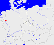
Diese Karte zeigt die Position oder den Umriss des Objekts. Haben Sie einen Fehler entdeckt? Dann würden wir uns über eine Nachricht freuen.
Übergeordnete Objekte
Legende
| | politische Verwaltung |
| | kirchliche Verwaltung |
| | gerichtliche Verwaltung |
| | Wohnplatz |
| | geographische Typen |
| | Verkehrswesen |
Übergeordnete Objekte
- Gräfrath (Stadtbezirk)
- Solingen (Kreisfreie Stadt)
- Düsseldorf (Regierungsbezirk)
- Nordrhein-Westfalen, Northrhine-Westphalia, North Rhine-Westphalia, Noordrijn-Westfalen (Bundesland)
- Deutschland, Bundesrepublik Deutschland, Tyskland, Germany, Allemagne, Vokietija, Герма́ния, Duitsland, Niemcy, Nemecká spolková republika, Federal Republic of Germany (Bundesstaat)
- Europäische Wirtschaftsgemeinschaft, Europäische Gemeinschaft, Europäische Union, Comhphobal Eacnamaíochta na hEorpa, Euroopan talousyhteisö, Európske hospodárske spoločenstvo, Communauté économique européenne, Comunidad Económica Europea, European Economic Community, Evropské hospodářské společenství, Europese Economische Gemeenschap, Comunità Economica Europea, Európske spoločenstvo, Europese Gemeenschap, Euroopan Yhteisö, European Community, Evropské společenství, Communauté européenne, Comhphobal Eorpach, Comunidad Europea, Comunità Europea, Európska únia, Europese Unie, Aontais Eorpaigh, European Union, Unión Europea, Euroopan Unioni, Evropská unie, Union européenne, Unione Europea (Staatenbund)
- Vereinte Nationen, Organización de las Naciones Unidas, Organisation des Nations unies, 联合国, Организация Объединённых Наций, الأمم المتحدة, United Nations, Verenigde Naties, Organizácia Spojených národov (Staatenbund)
- Britische Besatzungszone (Besatzungszone)
- Jülich-Kleve-Berg (Provinz)
- Preußen, Pruisen, Pruissen (Herzogtum Königreich Freistaat)
- Deutscher Bund, German Confederation (Staatenbund)
- Norddeutscher Bund (Staatenbund Bundesstaat)
- Deutsches Reich, German Empire, Duitse Rijk (Bundesstaat)
- Völkerbund, Société des Nations, League of Nations, Sociedad de Naciones, Folkeforbundet, 國際聯盟, Liga Narodów, Volkenbond, 国際連盟, Società delle Nazioni, Milletler Cemiyeti, Sociedade das Nações (Staatenbund)
- Rheinprovinz (Provinz)
- Preußen, Pruisen, Pruissen (Herzogtum Königreich Freistaat)
- Deutscher Bund, German Confederation (Staatenbund)
- Norddeutscher Bund (Staatenbund Bundesstaat)
- Deutsches Reich, German Empire, Duitse Rijk (Bundesstaat)
- Völkerbund, Société des Nations, League of Nations, Sociedad de Naciones, Folkeforbundet, 國際聯盟, Liga Narodów, Volkenbond, 国際連盟, Società delle Nazioni, Milletler Cemiyeti, Sociedade das Nações (Staatenbund)
- Alt-katholische Gemeinde Düsseldorf (Kirchengemeinde)
- Berg (Grafschaft Herzogtum)
- Solingen (Kreis)
- Düsseldorf (Regierungsbezirk)
- Nordrhein-Westfalen, Northrhine-Westphalia, North Rhine-Westphalia, Noordrijn-Westfalen (Bundesland)
- Deutschland, Bundesrepublik Deutschland, Tyskland, Germany, Allemagne, Vokietija, Герма́ния, Duitsland, Niemcy, Nemecká spolková republika, Federal Republic of Germany (Bundesstaat)
- Europäische Wirtschaftsgemeinschaft, Europäische Gemeinschaft, Europäische Union, Comhphobal Eacnamaíochta na hEorpa, Euroopan talousyhteisö, Európske hospodárske spoločenstvo, Communauté économique européenne, Comunidad Económica Europea, European Economic Community, Evropské hospodářské společenství, Europese Economische Gemeenschap, Comunità Economica Europea, Európske spoločenstvo, Europese Gemeenschap, Euroopan Yhteisö, European Community, Evropské společenství, Communauté européenne, Comhphobal Eorpach, Comunidad Europea, Comunità Europea, Európska únia, Europese Unie, Aontais Eorpaigh, European Union, Unión Europea, Euroopan Unioni, Evropská unie, Union européenne, Unione Europea (Staatenbund)
- Vereinte Nationen, Organización de las Naciones Unidas, Organisation des Nations unies, 联合国, Организация Объединённых Наций, الأمم المتحدة, United Nations, Verenigde Naties, Organizácia Spojených národov (Staatenbund)
- Britische Besatzungszone (Besatzungszone)
- Jülich-Kleve-Berg (Provinz)
- Preußen, Pruisen, Pruissen (Herzogtum Königreich Freistaat)
- Deutscher Bund, German Confederation (Staatenbund)
- Norddeutscher Bund (Staatenbund Bundesstaat)
- Deutsches Reich, German Empire, Duitse Rijk (Bundesstaat)
- Völkerbund, Société des Nations, League of Nations, Sociedad de Naciones, Folkeforbundet, 國際聯盟, Liga Narodów, Volkenbond, 国際連盟, Società delle Nazioni, Milletler Cemiyeti, Sociedade das Nações (Staatenbund)
- Rheinprovinz (Provinz)
- Preußen, Pruisen, Pruissen (Herzogtum Königreich Freistaat)
- Deutscher Bund, German Confederation (Staatenbund)
- Norddeutscher Bund (Staatenbund Bundesstaat)
- Deutsches Reich, German Empire, Duitse Rijk (Bundesstaat)
- Völkerbund, Société des Nations, League of Nations, Sociedad de Naciones, Folkeforbundet, 國際聯盟, Liga Narodów, Volkenbond, 国際連盟, Società delle Nazioni, Milletler Cemiyeti, Sociedade das Nações (Staatenbund)
Übergeordnete Objekte
Untergeordnete Objekte
Quicktext
GRAATHJO31ME
	 TEXT: ist bis 1806 Freiheit:TEXT,
	gehört ab 1819-04-30 bis 1929-07-31 zu object_311783 sagt source_190314 (Gräfrath),
	gehört ab 1929-08-01 bis 1999 zu adm_138122,
	gehört ab 1999 zu object_1139725,
	gehört bis 1806 zu object_287783,
	hat 1867-12-03 Einwohner 5306 sagt source_1165117 (S. 92),
	hat 1871-12-01 Einwohner 5424 sagt source_1165117 (S. 92),
	hat 1871-12-01 Haushalte 1195 sagt source_1165117 (S. 92),
	hat 1885-12-01 Einwohner 6296 sagt source_299630 (S. 98),
	hat 1885-12-01 Haushalte 1282 sagt source_299630 (S. 98),
	hat 1905-12-01 Einwohner 9028 sagt source_1135501 (S. 158),
	hat 1905-12-01 Haushalte 2016 sagt source_1135501 (S. 158),
	hat 1910 Einwohner 10066 sagt source_265044,
	hat 1925 Einwohner 10582 sagt source_190312,
	hat URL  https://de.wikipedia.org/wiki/Gr%C3%A4frath,
	hat ab 1961 bis 1993-06-30 PLZ W5650,
	hat ab 1993-07-01 PLZ 42653,
	heißt  (auf deu) Gräfrath,
	ist ab 1856-05-15 bis 1929-07-31 (auf deu) Stadt (Gebietskörperschaft) sagt source_190314 (Gräfrath),
	ist ab 1929-08-01 (auf deu) Stadtteil sagt source_190314 (Gräfrath);


