Greibnig, Grzybiany
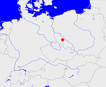
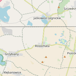
Diese Karte zeigt die Position oder den Umriss des Objekts. Haben Sie einen Fehler entdeckt? Dann würden wir uns über eine Nachricht freuen.
Übergeordnete Objekte
Legende
| | politische Verwaltung |
| | kirchliche Verwaltung |
| | gerichtliche Verwaltung |
| | Wohnplatz |
| | geographische Typen |
| | Verkehrswesen |
Übergeordnete Objekte
- Greibnig (Gemeinde)
- Rosenig (Amtsbezirk)
- Liegnitz (Landkreis)
- Liegnitz (Regierungsbezirk)
- Niederschlesien (Provinz Provinz)
- Preußen, Pruisen, Pruissen (Herzogtum Königreich Freistaat)
- Deutscher Bund, German Confederation (Staatenbund)
- Norddeutscher Bund (Staatenbund Bundesstaat)
- Deutsches Reich, German Empire, Duitse Rijk (Bundesstaat)
- Völkerbund, Société des Nations, League of Nations, Sociedad de Naciones, Folkeforbundet, 國際聯盟, Liga Narodów, Volkenbond, 国際連盟, Società delle Nazioni, Milletler Cemiyeti, Sociedade das Nações (Staatenbund)
- Schlesien (Provinz Provinz)
- Preußen, Pruisen, Pruissen (Herzogtum Königreich Freistaat)
- Deutscher Bund, German Confederation (Staatenbund)
- Norddeutscher Bund (Staatenbund Bundesstaat)
- Deutsches Reich, German Empire, Duitse Rijk (Bundesstaat)
- Völkerbund, Société des Nations, League of Nations, Sociedad de Naciones, Folkeforbundet, 國際聯盟, Liga Narodów, Volkenbond, 国際連盟, Società delle Nazioni, Milletler Cemiyeti, Sociedade das Nações (Staatenbund)
- Koischwitz (Standesamt)
- Liegnitz (Landkreis)
- Liegnitz (Regierungsbezirk)
- Niederschlesien (Provinz Provinz)
- Preußen, Pruisen, Pruissen (Herzogtum Königreich Freistaat)
- Deutscher Bund, German Confederation (Staatenbund)
- Norddeutscher Bund (Staatenbund Bundesstaat)
- Deutsches Reich, German Empire, Duitse Rijk (Bundesstaat)
- Völkerbund, Société des Nations, League of Nations, Sociedad de Naciones, Folkeforbundet, 國際聯盟, Liga Narodów, Volkenbond, 国際連盟, Società delle Nazioni, Milletler Cemiyeti, Sociedade das Nações (Staatenbund)
- Niederschlesien (Provinz Provinz)
- Preußen, Pruisen, Pruissen (Herzogtum Königreich Freistaat)
- Deutscher Bund, German Confederation (Staatenbund)
- Norddeutscher Bund (Staatenbund Bundesstaat)
- Deutsches Reich, German Empire, Duitse Rijk (Bundesstaat)
- Völkerbund, Société des Nations, League of Nations, Sociedad de Naciones, Folkeforbundet, 國際聯盟, Liga Narodów, Volkenbond, 国際連盟, Società delle Nazioni, Milletler Cemiyeti, Sociedade das Nações (Staatenbund)
- Schlesien (Provinz Provinz)
- Preußen, Pruisen, Pruissen (Herzogtum Königreich Freistaat)
- Deutscher Bund, German Confederation (Staatenbund)
- Norddeutscher Bund (Staatenbund Bundesstaat)
- Deutsches Reich, German Empire, Duitse Rijk (Bundesstaat)
- Völkerbund, Société des Nations, League of Nations, Sociedad de Naciones, Folkeforbundet, 國際聯盟, Liga Narodów, Volkenbond, 国際連盟, Società delle Nazioni, Milletler Cemiyeti, Sociedade das Nações (Staatenbund)
- Preußen, Pruisen, Pruissen (Herzogtum Königreich Freistaat)
- Deutscher Bund, German Confederation (Staatenbund)
- Norddeutscher Bund (Staatenbund Bundesstaat)
- Deutsches Reich, German Empire, Duitse Rijk (Bundesstaat)
- Völkerbund, Société des Nations, League of Nations, Sociedad de Naciones, Folkeforbundet, 國際聯盟, Liga Narodów, Volkenbond, 国際連盟, Società delle Nazioni, Milletler Cemiyeti, Sociedade das Nações (Staatenbund)
- Schlesien (Provinz Provinz)
- Preußen, Pruisen, Pruissen (Herzogtum Königreich Freistaat)
- Deutscher Bund, German Confederation (Staatenbund)
- Norddeutscher Bund (Staatenbund Bundesstaat)
- Deutsches Reich, German Empire, Duitse Rijk (Bundesstaat)
- Völkerbund, Société des Nations, League of Nations, Sociedad de Naciones, Folkeforbundet, 國際聯盟, Liga Narodów, Volkenbond, 国際連盟, Società delle Nazioni, Milletler Cemiyeti, Sociedade das Nações (Staatenbund)
- Preußen, Pruisen, Pruissen (Herzogtum Königreich Freistaat)
- Deutscher Bund, German Confederation (Staatenbund)
- Norddeutscher Bund (Staatenbund Bundesstaat)
- Deutsches Reich, German Empire, Duitse Rijk (Bundesstaat)
- Völkerbund, Société des Nations, League of Nations, Sociedad de Naciones, Folkeforbundet, 國際聯盟, Liga Narodów, Volkenbond, 国際連盟, Società delle Nazioni, Milletler Cemiyeti, Sociedade das Nações (Staatenbund)
- Kunice (Landgemeinde PL)
- Powiat legnicki (Landkreis)
- Województwo dolnośląskie (Wojewodschaft)
- Polen (Dritte Republik), Polen, La Pologne - IIIe République, Polska - III Rzeczpospolita, Polaca - Tercera República, Третья Речь Посполитая, Poland (Third Republic) (Republik)
- Europäische Wirtschaftsgemeinschaft, Europäische Gemeinschaft, Europäische Union, Comhphobal Eacnamaíochta na hEorpa, Euroopan talousyhteisö, Európske hospodárske spoločenstvo, Communauté économique européenne, Comunidad Económica Europea, European Economic Community, Evropské hospodářské společenství, Europese Economische Gemeenschap, Comunità Economica Europea, Európske spoločenstvo, Europese Gemeenschap, Euroopan Yhteisö, European Community, Evropské společenství, Communauté européenne, Comhphobal Eorpach, Comunidad Europea, Comunità Europea, Európska únia, Europese Unie, Aontais Eorpaigh, European Union, Unión Europea, Euroopan Unioni, Evropská unie, Union européenne, Unione Europea (Staatenbund)
- Vereinte Nationen, Organización de las Naciones Unidas, Organisation des Nations unies, 联合国, Организация Объединённых Наций, الأمم المتحدة, United Nations, Verenigde Naties, Organizácia Spojených národov (Staatenbund)
Übergeordnete Objekte
Untergeordnete Objekte
Quicktext
GRENIGJO81DE
	gehört ab 1999 zu object_1090458,
	gehört bis 1945 zu object_1090457,
	hat externe Kennung  SIMC:0364854,
	heißt ab 1945  (auf pol) Grzybiany,
	heißt bis 1945  (auf deu) Greibnig,
	ist (auf deu) Dorf,
	liegt bei 51.1947°N 16.275°O;